BRIEF FACTS ABOUT BAGUIO AND BAGUIO CITY INFORMATION
Moniker: Summer Capital of the Philippines, City of Pines
Region: Cordillera Administrative Region (CAR)
Foundation: 1900
Land area (How Big Baguio City is): 57.51 km2 (22.20 sq. mi)
Population: 345,366 (based on 2015 census)
Divisions: 129 barangays
Dialect: Ibaloi, Ilocano, Kankana-ey, and Ifugao
Religion: Roman Catholic, Episcopalian Church, and Iglesia ni Cristo (INC)
Climate: Mild (tropical monsoon)
Major industries: Tourism and commercial trade

Baguio, officially called the City of Baguio, is a first-class and highly-urbanized city located in the province of Benguet in the Northern Luzon map. Baguio was formerly the provincial capital of Benguet, from 1901 to 1916, until it was converted into a chartered city. But the most common Baguio description is that it is one of the best cities to visit up North.
Now, Baguio is administratively separate from Benguet, although it remains as a tourist spot and the economic center for both the province and the entire Cordillera region. It is considered as the convergence zone of neighboring areas.
People from different provinces and countries visit Baguio like Tagaytay for its cold climate, history, culture, and native products. The Manileños, in particular, visit the place to escape the heat, noise, crowd, and the overall chaotic atmosphere in the metropolis. Indeed, the Baguio altitude is perfect for a highland retreat in the Grand Cordillera as well as a perfect spot for those Instagram worthy travel photos.
Etymology and other Baguio City facts, Where did Baguio name came from and What is Baguio City known for?
In 1900, the former former name of Baguio city was known then as an Ibaloi village called Kafagway, was designated a hill station during the American occupation. The Baguio name comes from the Ibaloi term bagiw or moss. American soldiers Hispanicized the term to “Baguio.” This also served as the origin of Baguio City.
Geography
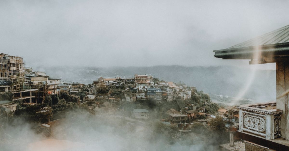
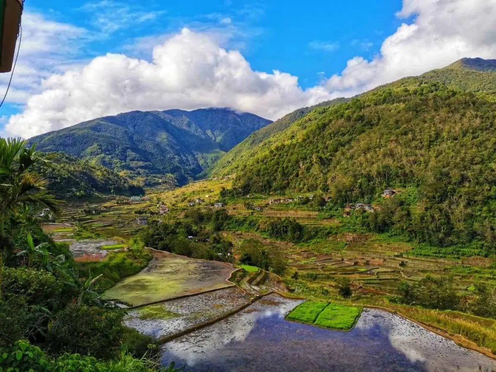
Baguio City is located in Luzon’s tropical pine forests ecoregion. Its location makes it conducive for growing moss, orchids, and pine trees where it gets its moniker from. From a grassy marshland, the city is transformed into being one of the cleanest and greenest highly urbanized cities in the Philippines.
Baguio is nestled in the Cordillera Central mountain range, about 250 kilometers away from Metro Manila. This explains various developments, including the picturesque housing on uneven and hilly terrain in the northern part of the city. This forms part of the developed portion of Baguio, corresponding to the plateau and rising to an elevation of 1,400 meters.
Baguio City is landlocked within Benguet province. It is bounded by La Trinidad on the north, Itogon on the east, and Tuba on the west and south.
During planning, Daniel Burnham, an American architect and urban planner commissioned by the then-American Governor Luke E. Wright, designated the city hall as the reference point. From here, the city limits extend about 8.2 kilometers and 7.2 kilometers east to west and north to south, respectively.
While at it, becoming the country’s summer capital was figured into the plan. This explains the extensive development of summer residences in Baguio City. The city houses the summer residences of the executive branch (president, vice president, senate president, and house speaker).
There is also the Cabinet Hill, where the Supreme Court, Court of Appeals and the Cabinet Secretaries’ cottages are found. They hold summer sessions in Baguio City and live in the accommodation for the duration of the sessions.
Burnham designed a health resort for the American soldiers and civilian employees known as the Burnham Plan. This is a place where they could find respite against sweltering heat in the lowland areas. The Burnham Plan effectively altered the original mountain settlement plan for Baguio now that road networks and park systems are integrated into the said plan. It envisioned the place as a compact garden city with only up to 30,000 residents.
Environment
The natural bounties are Baguio City’s main attraction. Aside from the cool climate, it boasts of the clean environs. For instance, it has a total of five forest reserves, three of which are watersheds providing for the people’s water needs. These include as a source of irrigation for cultivating cultural lands. Nine springs contribute to the water supply.
As part of its environmental commitment, pine forests are maintained and prioritized by the local government.
Climate
People visit Baguio City to experience its cool climate, and good air quality which falls under the tropical monsoon category under the Köppen climate classification. It is mainly because of the city’s high elevation; the temperature is 8°C cooler than that of the lowland areas.
The average temperature is from 15 to 23°C, and even during the warmest days of the year, it rarely exceeds 26°C. As a matter of fact, the warmest recorded temperature was 30.4°C on March 15, 1998, during El Niño, while the coldest recorded temperature was 6.3°C. When the temperature drops, frost forms from moisture.
The chilly weather is reminiscent of spring. Nevertheless, it is best to visit the city from November to April during the dry season. Rainfall is at its lowest during this time, so roaming around the city is possible. This explains why the cool, dry season is considered as Baguio’s peak season for tourist arrival.
Baguio receives the biggest amount of rainfall, which may happen anytime between June and October. The rainfall is twice the volume that of in Metro Manila.
Landscape
Baguio City’s overall design is inspired by the City Beautiful movement characterized by broad streets and avenues. Before it had contemporary architecture, though, the city endured various calamities in the past.
The local government has to rebuild the city after World War II has severely damaged it. The majority of the historical buildings were renovated based on what’s left for its constructibility. However, not all buildings have been reconstructed; some were even left to deteriorate.
Another natural disaster to hit Baguio City was an earthquake in 1990 that further devastated some 19th-century buildings and structures like hotels, factories, and universities. A total of 28 buildings were severely damaged.
Since the Americans stationed here, the architectural built is primarily American. Camp John Hay, Baguio City Hall, and Teacher’s Camp are three of the examples of Westernized architecture.
Nonetheless, some buildings still have Spanish remnants such as La Azotea and Porta Vaga Mall.
Baguio City government and other groups took the initiative to preserve the structures, especially the city hall, which can be considered a historic site.
Demographics
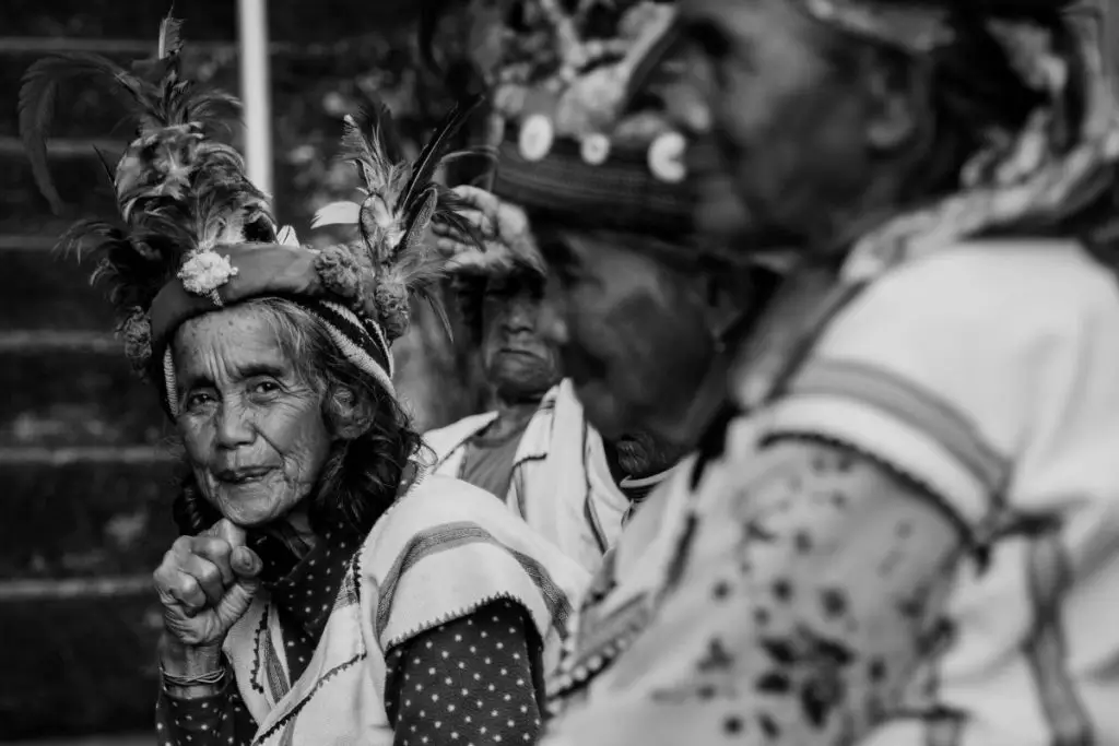
The Ibaloi people originally inhabited the city. However, when building and reconstruction started in the early 1900s, other settlers began to flock in Baguio City. Aside from the Americans (Merikano) and mestizos, the Igorot tribes and lowlander Ilokanos started to inhabit the place.
Japanese and Chinese laborers, whose heads of the families were laborers when the Kennon Road was being built, chose to settle in the city.
Thereby, Baguio City is a melting pot of peoples and cultures.
As of 2015, the city has a total population of 345,366 in 87,731 households with a density of 4.6 members per household. Furthermore, Baguio City has a relatively young demographic wherein about 65.5% of the population is below 30 years old. About 51.3% of the people are female, while the remaining 48.7% are male. Native residents in Baguio are called the Ibagiw people.
The population almost tripled during the influx of tourists and transients, usually from Panagbenga season to the Lenten period.
The locals speak Ibaloi or Ilocano, although the national language, Filipino, is also widely spoken.
Economy
Baguio teems with business and economic opportunities, and it has the right resources to support investments.
It has an extensive retail industry. For one, ukay-ukays (thrift shops) are considered to originate from the city. People go here to experience the cool climate and its ukayan, taking advantage of the diverse and inexpensive commercial products. The place is a haven for bargain hunters indeed because it has the ukays on one hand and night markets on the other hand.
Baguio City’s night market happens at Harrison Road, Session Road, and other streets in the area. The night market starts at 11 pm. Ready your pocket because this is where you will find clothes, shoes, and accessories for cheap. Some thrift stores sell vintage and branded items at bargain prices.
Two of Baguio City’s premier commercial hubs are Baguio Public Market and Maharlika Livelihood Center. Other shopping centers include Baguio Center Mall, Cooyeesan Plaza, Abanao Square, Centerpoint Plaza, Cedar Peak Mall, Ayala Technohub Retail Plaza, and SM City Baguio.
Abanao Street, Session Road, Magsaysay Avenue, and Harrison Road are the city’s commercial center, though. Here, one will find clusters of cinemas, restaurants, department stores, and hotels.
The city market remains to be one of the most famous destinations when in Baguio City. This is where one will find diverse locally sourced products from walis tambo (brooms) to fresh strawberries and vegetables, primitive wooden carvings, and silver jewelry pieces. Souvenirs made from colorful woven fabric and hand-strung beads are also among the choices. The majority of the products are from Benguet province where carving and weaving industries thrive until today.
Speaking of which, Baguio City is Benguet province’s primary commercial hub. Mining, which started in the 1930s when Kennon Road was opened to vehicular traffic, and agricultural products are processed and sold in the city before these are distributed to the lowland areas. This is in line with the local government’s agenda to make the City of Pines as a creative center for crafts and folk arts.
The economic landscape is also composed of its distinct dining culture. Retail and dining combinations abound in Baguio including Session Road, Teacher’s Camp, Bonifacio Street, Mines View Park, and Baguio Fastfood Center which is the closest to the public market.
As an investment destination, Baguio City has the infrastructure to support certain business operations especially within the BCEZ or the Baguio City Economic Zones, a PEZA (Philippine Economic Zone Area)-accredited business and industrial park. BCEZ is specially located in Barangay Loakan, between the Philippine Military Academy (PMA) and Camp John Hay Country Club. Knitted clothing, transistors, vehicle parts, computer parts, and electronics are manufactured here. The second-largest exporter in the Philippines, Texas Instruments Philippines, is a key relocated at BCEZ.
Technologically-driven industries proliferate in Baguio as well, providing livelihood to the locals and transients. These are business process outsourcing (BPO) and online English tutorial services.
Infrastructure
Baguio has a well-established road network. First, it has Loakan Airport, which serves the entire city. Nevertheless, it is a trunkline airport that cannot accommodate commercial flights. It can only cater to helicopters, turboprops, piston aircraft, and light business jets.
Several bus operators service people going to Baguio from NCR and provinces like Cavite. The Summer Capital of the Philippines is accessible through North Luzon Expressway (NLEX) from Bulacan to Tarlac and TPLEX (Tarlac-Pangasinan-La Union Expressway) from Tarlac to La Union.
Three main roads are going to Baguio: Kennon Road, Aspiras-Palispis Highway (or Marcos Highway), and Naguilian Road (or Quirino Highway). Baguio is connected to the lowlands through Asin Road. All roads traverse through Tuba, Benguet.
Kennon Road is considered the most dangerous route because of its zigzagging road but the most picturesque. This is also the most popular among tourists as it passes by the Lion’s Head, the default “entrance marker” going to Baguio. Ifugao artist, Anselmo Bayang Day-ag, carved the limestone sculpture as commissioned by the Lions Club Baguio chapter.
Marcos Highway is the widest and safest route because of the less winding road. Quirino Highway, which is usually taken by people from the north, is the longest among the three.
Meanwhile, when going around the city, there are taxicabs and jeepneys.
There are also plans for installing cable cars and monorail. The cable car installation is on the initial feasibility assessment stage, though, it will only push through once the planned cable car installation in Metro Manila is already completed.
The monorail, on the other hand, will be from Baguio to La Trinidad.
These future transportation mode projects aim to decongest traffic while also boost tourism in Baguio and nearby towns and provinces.
Baguio Culture and Traditions
Arts, museums, and festivities that are truly unique to Baguio are other reasons why travelers flock the city. Even Filipino artists themselves have chosen Baguio as their home. From the 1970s to the 1990s, artists were drawn to the charm of the city.
Some of them are Benedicto Cabrera who is also known as Bencab, a painter and National Artist for Visual Arts; Ben Hur Gorospe Villanueva, a sculptor and painter; and Kidlat Tahimik, a filmmaker and writer, who is also the Father of Philippine Alternative Cinema and National Artist for Film.
Artists like them are honored through the Baguio Arts Festival, an annual event showcasing the talent of the Filipino artists.
Bencab has his own museum called Bencab Gallery and Museum located at the foothill and endows a panoramic view of the rainforest and garden. Ethnographic masterpieces such as bowls, pipes, and spoons are also featured in his museum in addition to paintings and sculptures.
There are several other museums and arts and cultural centers geographically dispersed in the city. These are the Baguio Museum, Museo Kordilyera, Laperal White House, SLU Museum of Arts and Cultures, and Emilio F. Aguinaldo Museum.
Baguio is a member of the 180-cities strong UNESCO Creative Cities Network (UCCN), a project promoting cooperation between cities that regard creativity as central to its urban development. These are the cities that integrate culture into their sustainable urban development planning. For Baguio, these creative endeavors are wood carving, traditional weaving, tattooing, and silver craft.
Tourism
Baguio serves as Cordillera’s tourist hub—a gateway to other tourist destinations in the north such as Sagada, Mount Pulag, and Banaue. In fact, its tourism promotions highlight nearby attractions and places of interest like La Trinidad.
Baguio City’s cultural heritage is also central to the main tourism activities.
The Panagbenga Festival, or the annual flower festival, honors the local floral industry as a significant contributor to the city’s economy. Panagbenga has a deeper meaning for the Ibagiws, though—it was created to inspire the people to rise against the devastation of the 1990 Luzon earthquake.
The festival features a parade of vibrantly colored floats covered in flowers and street dance performances by dancers dressed in flower-inspired costumes every February. The cultural part is the dance, which is inspired by the Ibaloi dance of celebration called Bendian. The festival attracts up to a million local and foreign spectators every year.
As a top tourist destination in the Philippines, Baguio City was hailed as the Traveller’s Choice Destination Award (Asia category) by TripAdvisor in 2011. It bested twenty-five other Asian destinations. Five of the best Baguio tourist destinations are Burnham Park, Mines View Park, Teacher’s Camp, The Mansion, and Baguio Cathedral.
Moreover, aside from comfort food like strawberry and vegetables and sampling strawberry-flavored taho on the side, tourists often go home with lots of pasalubong (take-home treats). Good Shepherd products such as strawberry jam, peanut brittle, ube jam, and sesame crunch are popular. For non-foodie items, hardwood carvings such as bulul (rice gods) and the infamous barrel man and woven articles like pasiking (native backpack) and baskets are common.
Entertainment
Besides all the exciting activities noted above (i.e., embarking on a gastronomic adventure, attending the flower festival, strawberry-picking, and thrift shopping), Baguio City is also rife with nightlife activities.
Chill-out bars abound, particularly at the Nevada Square. There are also hall-in-the-wall bars outside Nevada Square where one can catch their favorite local and indie bands doing a set or two.
Baguio has an ever-progressive real estate market, and Crown Asia is at the core of such progress. Crown Asia has three condominium buildings in Baguio, namely Brenthill, Canyon Hill, and Pinehill.
Brenthill is a one-tower, ready for occupancy (RFO) condo located near the main landmarks like Baguio Cathedral, Teacher’s Camp, the Botanical Gardens, the Pink Sisters, and the public market.
Canyon Hill is a one-tower pre-selling condo in Pacdal Road, Baguio City. It offers a breathtaking view of the Cordillera Mountains.
Pinehill is another 12-story one-tower pre-selling condo in Baguio City; it is located in Outlook Drive. The residence is master-planned as a vertical village in the mountainside. It offers a panoramic view of the pine forests.